Satellite Imaging
Satellite imaging technology has been recognized as a valuable tool for viewing, analysing, characterizing, and making decisions about the environment and surroundings. The technology, which has been predominantly used for military purposes, is now also used for a variety of environmental analysis applications that relate to land, ocean and atmosphere issues. As your trusted Intelligence experts, Shoghi now offers a wide range of sub-meter imagery product levels intended to match your specific area of interest – anywhere in the world.
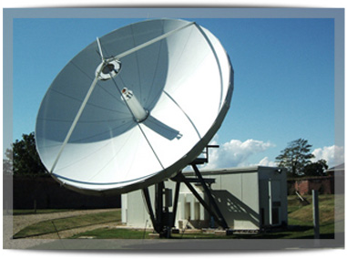
Image Reception Ground Station
Image Reception Ground Station is one of the most critical requirement of a developing country in order to regularly receive remote sensing data from an Optical/SAR sensor so as to process and receive location based timely intelligence. Shoghi, with its expertise in establishing satellite ground station, can provide turnkey solution to establish High Resolution Meter/Sub-Meter Image Reception Ground Station for direct acquisition and processing of remote sensing satellites data.
Such a facility will enable cost effective and quick access to remote sensing data from around the world that can be used to address crucial information needed during defence planning and management and various other activities such as natural resource management, agricultural planning, environment modelling and many more applications.
On-Demand High Resolution Satellite Data Acquisition
Shoghi is focused on serving the needs of our customers from diverse industries by providing high resolution satellite imagery, both Optical and SAR. For Customers who are starting up in the field of Satellite Image Reception and would not like to proceed with owning a Ground station for the time being, Shoghi can provide them facilities for On-Demand Satellite data acquisition whereby we accept request by our customers to acquire data of a target area at a given time. Shoghi provides data acquisition services along with data processing and distribution to any site in the world. We are equipped with state of the art setup to acquire and process high resolution satellite images obtained from low earth orbiting satellites having on board SAR and optic camera payload. The obtained images are of meter and sub meter resolutions.
High Resolution Satellite Archival Data On-Demand
Satellite imaging data has its vast applications in planning and decision making. The archived data is utilised in strategizing, analysing and preparing the blue print of the future plans in relation to various aspects. The archived data of high resolution images serves as the initial input and base for information gathering and decision making. Shoghi is focused on serving the needs of our customers from diverse industries by providing high resolution satellite imagery, both Optical and SAR. Imagery is available on demand from Shoghi’s extensive data archives. We offer archived data of high resolution satellite imagery from all the major commercial satellites.